Locations
Access to our location API , which will provide you with the Coordinates (latitude/longitude) of Ports, Terminals and Berths.
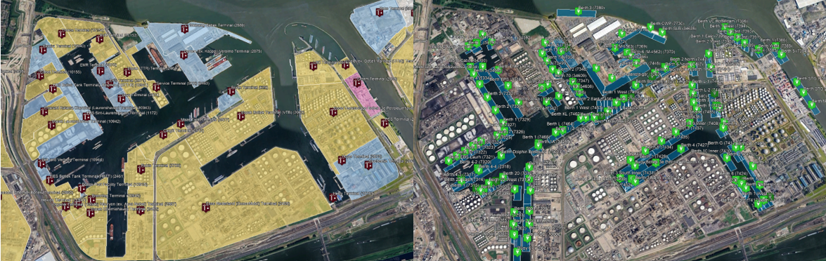
In the advanced version of Location API we have Polygon API will provide geographical boundary of Port, Terminal and Berth which are geofenced based on various Information. Overall, the Location API and its advanced Polygon API offer powerful tools for accessing location data and spatial boundaries of ports, terminals, and berths. This information is essential for optimizing maritime operations, enhancing safety and security, and facilitating effective decision-making in the maritime domain. This polygon can be used to identify
- The list of Vessels within the Port, Terminal and Berths.
- Track the Vessel arrived and departed at Port, terminal and Berth
- Calculate the Avg waiting time, Turnaround time etc
The API has to be called separately as per hierarchy of Port , Terminal and Berths
- The Locations API has no restrictions whatsoever with regards to the history.
- The API may be called once without providing any parameters to facilitate the initial load.
- Thereafter, the [start_dt] may be used to GET data modified on or after that date.
- Please replace/update this data by using the [berthCode] identifier.
- At all times, you may refresh the entire dataset by following (b) as and when required.
- Marcura Recommendation: Records may be retrieved Weekly
What made this section helpful for you?
What made this section unhelpful for you?
Base URL
Production:
Sandbox:
Endpoints
api-pd/location/ports?iso2code=AE,IN&port_code=5215,3803&start_dt=1990-01-01
api-pd/location/terminals?terminal_code=11324,4641&terminal_type=Bulk&iso2code=AE,IN&port_...
api-pd/location/berths?terminal_code=2470&berth_code=7138&berth_type=Berth&iso2code=NL&por...